I don't suspect too many people remember what they were doing at 8:32am (PST) on Sunday, May 18, 1980...
The
weather in Portland has improved a great deal lately, so I wanted to
jump at the chance to go shooting when I saw that the weatherman was
predicting sunny skies and warm temperatures. It's not Vegas hot, mind
you, but it's definitely a bit warmer. I like the slow and steady rise
in temperatures. Maybe it'll really heat up by summer but, for now, it's
comfortably mild. In short, I'm glad it's warming up.
Anyway...
Anyway...
When
I woke up Saturday morning, I looked out my bedroom window. The sky was
clear and off in the distance I could see Mount St. Helens, roughly 60
miles or so as the crow flies. Something about the way it looked on this
particular Saturday morning convinced me that it would have to be the
target of my next outing, and my next outing would be Sunday; Easter
Sunday.
I woke up around 5:30am, and quickly put on a pot of coffee. Nothing was going to happen without that. I eased into my morning, and then began the preps to leave.
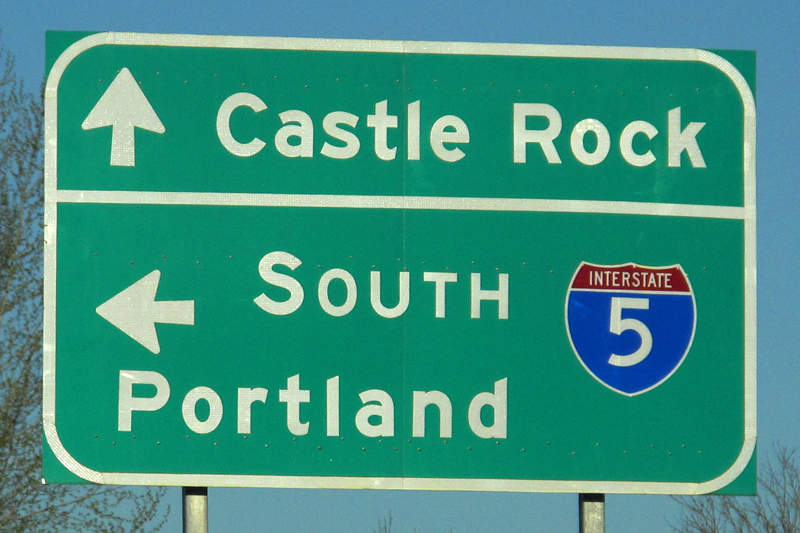
With my gear all packed, I gassed up the truck and headed north up I-205, eventually merging onto I-5 somewhere north of the Washington state line. It didn't seem like I'd been on the road all that long when I took the exit at the thriving metropolis of Castle Rock (pop: 1,262) onto Route 504.
With my gear all packed, I gassed up the truck and headed north up I-205, eventually merging onto I-5 somewhere north of the Washington state line. It didn't seem like I'd been on the road all that long when I took the exit at the thriving metropolis of Castle Rock (pop: 1,262) onto Route 504.
Almost
immediately, the scenery changed. I could tell I was moving far away
from the scenery of the freeway and the rest stops, and moving up into
the mountains.
To
be completely honest, I wasn't sure how far I was going to get. Just
about everything I found online said that Route 504 was closed. But the
mercury has been climbing a bit lately, so I was hopeful that the lower
elevations would be accessible. If not, I would be happy with having
made it to Castle Rock, and I would shoot there. To my surprise, though,
the roads were perfectly clear.
And,
for the nice old lady outside Mrs. Beesley's Burger Barn, who swore up
and down that there is no Route 504 in Washington state, I beg to
differ:
 |
| Found it... |
The road quickly narrowed into two lanes, but that didn't present much of a problem, as there were few cars out on the road. The fact that it was relatively early was one factor, and the fact that it was Easter Sunday another. Whatever the reason, it was an enjoyable drive, to be sure. I made a point to stop along the way and peel off a few frames:
 |
| A roadside lake along Route 504... |
 |
| Reflections in a lake along Route 504... |
There
are a couple of visitor centers along the drive; three, and only one of
them, Johnston Ridge Observatory, is still closed. The Mount St. Helens
Visitor Center is open, and is a neat place to learn more about
volcanoes (Mount St. Helens in particular). If you have a little bit of
time, you can also walk along their wetland boardwalk trail, from which
Mount St. Helens is visible:
 |
| Entrance to the Visitor Center... |
 |
| The Mount St. Helens Visitor Center, which is open year-round... |
 |
| An exhibit inside the Visitor Center. To me, these figures, which are incredibly detailed, appear to be covered in ash... |
 |
| The mountain, as seen from the Visitor Center's wetland boardwalk... |
It's
still early in the season here and, despite the roads being clear, many
of the roadside observation points are not. I wanted to pull into
several, but the snow had been plowed off the road into the entrance and
exit of many of them. I did manage, though, to pull into the Castle
Lake observation area for my first glimpse at the mountain:
 |
| Snowy, but definitely passable... |
 |
| Mount St. Helens, still a considerable distance away... |
There
were some areas where there was no observation point, but still enough
room to simply pull over to the side of the road and get some pictures:
 |
| Mount St. Helens... |
 |
| The Explorer... |
Of the three visitor centers, one remains closed: Johnston Ridge Observatory. I found this one, Hoffstadt Bluffs, at mile marker 27. There was a restaurant that wasn't open yet, and a gift shop, but I stopped for the view:
 | ||
| I want to come back here for a helicopter tour of the mountain... |
 |
| The view of the mountain, and the still-devastated North Toutle Valley, from Hoffstadt Bluffs... |
As
big as the mountain is, it's almost as if you never get any closer to
it. I can see the mountain from my bedroom window, and I'm amazed that,
after all the driving I'd done, I was still miles from it. Undeterred, I got back in the truck and continued towards the mountain.
As
I drove, I couldn't help but think about what things were like here on
May 17, 1980. There were indications that something was going on with
the mountain. There had been eruptions and earthquakes, and authorities
had taken steps to evacuate the area. Had it not been for their efforts,
far more than 57 people would've lost their lives.
Before too long, I came upon a very long, and very nigh and narrow bridge, spanning over Hoffstadt Creek:
 |
| Hoffstadt Creek Bridge... |
 |
| Hoffstadt Creek Bridge. At 370 feet high and 2,340 feet long, it's the longest and highest bridge along Route 504... |
The original bridge was wiped out by the eruption, and the replacement wasn't opened until 1991. And, just as you begin your trip onto the bridge, you're greeted by an ominous sign:
 |
| This sign is located 15 miles from the mountain... |
As I continued my drive, the fact that how anything that was here 33 years ago is now dead was not lost on me. Everything was
destroyed. Animals, plant life... people. In a matter of minutes, it
was all gone. Even the mountain itself, once a majestic peak of 9,677
feet, suffered. After the eruption, the mountain stands at only 8,363
feet. Over 1,300 feet of mountain was simply blown away and ceased to
exist. If you need that put into perspective, New York's Empire State
Building is 1,454 feet tall, only 140 more feet than Mount St. Helens
lost in the blast.
Two
of the more notable names of people lost in the blast are Harry Truman
(no, not the President) and David Johnston. Truman was the owner of the
Mount St. Helens Lodge on Spirit Lake. When admonished to leave, he
refused, insisting that the timbers and the lake which sat between him
and the mountain would be enough to protect him and his lodge.
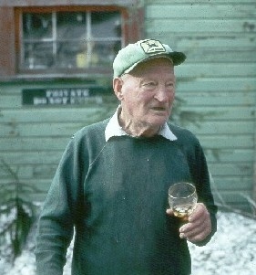 |
| Harry Randall Truman: October 30, 1896 - May 18, 1980 (photo from Wikipedia) |
Truman, along with his lodge, was buried under more than 150 feet of volcanic debris on May 18,1980. His body has never been recovered.
Another notable is David A Johnston, who was a volcanologist with the United States Geological Survey. Johnston was one of the first scientists on scene when St. Helens started acting up in March of 1980, and he was at the Coldwater II observation post on the morning of May 18, 1980. Being a full six miles from the mountain, it was believed that he was safe.
His body has also never been recovered, although parts of his trailer were discovered in 1993, ironically, during the construction of the road which leads to the observatory that now bears his name.
His body has also never been recovered, although parts of his trailer were discovered in 1993, ironically, during the construction of the road which leads to the observatory that now bears his name.
 |
| David Johnston, age 30, some 13 hours before his death... (photo by Harry Glicken) |
I continued to make my way towards the mountain, and took the turn for the Johnston Ridge Observatory and Coldwater Lake. The road to Johnston Ridge was still gated, although I'm not certain why. I'm assuming it was simply due to staffing, since the roads up to this point, only seven miles from the observatory, were absolutely and completely passable.
 |
| The road which leads to the Johnston Ridge Observatory... |
 |
| Coldwater Lake Recreation Area... |
Coldwater Lake lies to the northwest of Mount St. Helens, although it hasn't always. At 8:32am, May 17, 1980, Coldwater Lake didn't even exist. The volcanic runoff, which clogged Coldwater Creek after the eruption, is what was responsible for the creation of Coldwater Lake and nearby Castle Lake.
 |
| A self-portrait at Coldwater Lake... |
 |
| Coldwater Lake, seven miles from Mount St. Helens... |
 |
| The water is perfectly crystal clear here... |
 |
| The boardwalk on Coldwater Lake... |
After leaving Coldwater Lake, I made a left and drove over to a nearby area, unsigned, to do a little walking around. As I hiked down the trail, I couldn't help but wonder if the long-dead lunks of wood I saw were once trees that were vibrant and alive before the eruption. I couldn't help but wonder if the extremely large boulders I was seeing were deposited where they were by the force of the mountain face blasting apart. The scope of the disaster is something which, quite simply, is difficult to digest. It was actually nothing different than what the earth has been doing for hundreds of millions of years.
The difference, of course, is that this time we were able to watch it happen.
After about a half hour of hiking and taking pictures, I was getting a bit hungry, so I opted to pack up the gear and head back towards civilization. I drove back past Coldwater Lake and over Hoffstadt Creek Bridge, all the while craning my neck to make sure I wasn't missing out on some view that I didn't see when I was driving the other way.
I eventually made my way back up to Hoffstadt Bluffs, and the appropriately named Fire Mountain Grill.
I hadn't eaten since breakfast; some eight hours earlier, so I was beginning to get more than a bit hungry. Being that this is the pacific northwest, I couldn't just go with any old burger. So, I opted for the Elk Burger.
Oh.
My.
God.
After lunch, I decided to walk around the grounds for a little while. I found an area known as "Memorial Grove" and, as you might suspect, there was a memorial to the 57 people who lost their lives the morning of May 18, 1980:
I took a walk to an observation deck that was hidden in the trees, but which looked out over the Toutle River Valley. What was once a river is now gray ash. There was no access to the valley floor; no way to get closer. I wish I could've, though:
As I walked to the truck, I couldn't resist getting just one more shot of the mountain. It's one of those things that, if you took a thousand pictures of it, you'd see a thousand different things. I just hated to think I would miss something:
At this point, I packed the gear away and decided it was time to head home. I'd been shooting all day, and I still had a little bit of a drive waiting for me. I needed to get back down to the freeway and into Castle Rock to gas up and get some coffee.
Up here in the Pac Northwest, people can get mighty uppity about things, like coffee.
And guns:
So, gassed up and loaded with enough caffeine to wake the dead, I headed south on I-5. During the drive, I tried to put the entirety of the day into proper perspective.
The entire area has an awesome air about it. It's as if the entire area, from the town of Castle Rock to the mountain, serves as a memorial to the 57 people who lost their lives that day and, in some ways I suppose, it is.
But it's also a reminder that, on the one hand, no matter how much we think we matter, how much impact we think we have, we're insignificant in the grand scheme of things. The earth will do what she wants to do, when she wants to do it and nothing we do, or want to do, or intend to do, or wish we could do will matter an iota.
No, I don't remember what I was doing at May 18, 1980 at 8:32am (PST). As I said, I doubt too many of us do. But the drive I made to Mount St. Helens also reminded me that things we do, while seemingly insignificant, can also be profound.
David Johnston did just that. He believed that scientists should be willing to risk their lives so that "regular" folks; people like you and me, don't have to.
Even as he spoke the words, he probably had no idea that those words would be his last. He probably had no idea that his words would be so profound that they would be quoted for decades to come. He probably had no clue that his simple warning to a city some 50 miles to the south would be the words that would echo through the ash and the dirt and the devastation, to warn them; to let them know that, at 8:32am (PST) on May 18, 1980, what they feared was, in fact, happening.
"Vancouver, Vancouver... This is it!"
The difference, of course, is that this time we were able to watch it happen.
After about a half hour of hiking and taking pictures, I was getting a bit hungry, so I opted to pack up the gear and head back towards civilization. I drove back past Coldwater Lake and over Hoffstadt Creek Bridge, all the while craning my neck to make sure I wasn't missing out on some view that I didn't see when I was driving the other way.
 |
| Mount St. Helens in the side view... |
I eventually made my way back up to Hoffstadt Bluffs, and the appropriately named Fire Mountain Grill.
 |
| The Hoffstadt Bluffs Visitor Center... |
I hadn't eaten since breakfast; some eight hours earlier, so I was beginning to get more than a bit hungry. Being that this is the pacific northwest, I couldn't just go with any old burger. So, I opted for the Elk Burger.
Oh.
My.
God.
 |
| Unbelievably tasty... |
After lunch, I decided to walk around the grounds for a little while. I found an area known as "Memorial Grove" and, as you might suspect, there was a memorial to the 57 people who lost their lives the morning of May 18, 1980:
 |
| This plaque was dedicated 20 years to the day of the eruption of Mount St. Helens... |
 |
| The names of the 57 people who died in the eruption of Mount St. Helens on May 18, 1980... |
I took a walk to an observation deck that was hidden in the trees, but which looked out over the Toutle River Valley. What was once a river is now gray ash. There was no access to the valley floor; no way to get closer. I wish I could've, though:
 |
| The Toutle River Valley... |
As I walked to the truck, I couldn't resist getting just one more shot of the mountain. It's one of those things that, if you took a thousand pictures of it, you'd see a thousand different things. I just hated to think I would miss something:
 |
| A final shot of Mount St. Helens... |
Up here in the Pac Northwest, people can get mighty uppity about things, like coffee.
And guns:
 |
| I wonder if Starbuck's knows... |
So, gassed up and loaded with enough caffeine to wake the dead, I headed south on I-5. During the drive, I tried to put the entirety of the day into proper perspective.
The entire area has an awesome air about it. It's as if the entire area, from the town of Castle Rock to the mountain, serves as a memorial to the 57 people who lost their lives that day and, in some ways I suppose, it is.
But it's also a reminder that, on the one hand, no matter how much we think we matter, how much impact we think we have, we're insignificant in the grand scheme of things. The earth will do what she wants to do, when she wants to do it and nothing we do, or want to do, or intend to do, or wish we could do will matter an iota.
No, I don't remember what I was doing at May 18, 1980 at 8:32am (PST). As I said, I doubt too many of us do. But the drive I made to Mount St. Helens also reminded me that things we do, while seemingly insignificant, can also be profound.
David Johnston did just that. He believed that scientists should be willing to risk their lives so that "regular" folks; people like you and me, don't have to.
Even as he spoke the words, he probably had no idea that those words would be his last. He probably had no idea that his words would be so profound that they would be quoted for decades to come. He probably had no clue that his simple warning to a city some 50 miles to the south would be the words that would echo through the ash and the dirt and the devastation, to warn them; to let them know that, at 8:32am (PST) on May 18, 1980, what they feared was, in fact, happening.
"Vancouver, Vancouver... This is it!"


I remember well that day in 1980. I watched it happen with my family and experienced how day seemingly turned into night when the falling ash reached us. It was surreal and an experience that I hope I never forget.
ReplyDelete